all systems go

after talking with a classmate from my master's course, the area of colombia called Sierra Nevada del Cocuy is filled with military people and is safe to traverse. so next month, andrea and I will be doing the Guican-El Cocuy trek, as described in the LonelyPlanet Guide to Colombia (1995 edition). it's a difficult trail and the guidebook says it is a minimum of 7 days hiking. to quote the description:
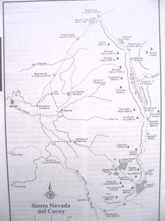
'This is one of the most spectacular treks the Colombian mountains have to offer. On the way, you'll see more than 20 snow-capped peaks, a dozen beautiful mountain lakes, marvellous frailejon-filled valleys, waterfalls, glaciers, and abundant flora. You'll need six to seven days to complete the whole circuit as described below, but of course it's up to you how long you wish to walk and where you want to camp. Keep in mind that the changeable weather may affect your plans considerably." (The article mentions later that the only period of reasonably good weather is from December to February. The rest of the year is rainy and snowy.) the picture is of the trail map from the guidebook. the trail starts in Guican (to the left, middle of the page) and continues in a clockwise fashion until Cocuy (below Guican). the trail is marked on the page by a dotted line.
in case it's too difficult to see details, some stops along the way include: lakes/rivers: Rio Cardenillo, Laguna Grande de los Verdes, Laguna de la Plaza, Laguna de la Isla, Laguna del Avellanal, Valle de los Cojines, La Cascada del Rio Ratoncito, Laguna del Rincon, and the Laguna Hoja Larga. mountains and elevations: Guican (5000m), Boqueron de la Sierra (4850m), Ritacuba Norte (5200m), Ritacuba Negro (5250m), Ritacuba Blanco (5060m), Puntiagudo (5060m), El Picacho (5030m), San Paulin Norte (5180 m), El Castillo (5100m), San Paulin Sur (5180m), Boqueron del Castillo (4800m), Concavito (5100m), Concavo (5200m), Portales (4850m), Toti (4900m), Diamante (4800m), Pan de Azucar (5150m), Pulpito del Diablo (5120m), and Campanillas (4800m).
the plan is to hire a guide in el cocuy (the town) and go from there. from what the brit in my class said, guides are easy to come by and are pretty cheap. but all things considered, if we do the 7 day trail it would be very difficult. i'm certainly not an expert trekker and neither is andrea. i hope not, but what i think will end up happening is we'll do a few days of hiking and camping through some of the more popular trails, toward the end of the trek (bottom right corner of the photo).
some other people have hiked around this part of colombia. you can see some info about their trek here and a travelogue here, which also includes pictures.


1 Comments:
Esta bien, vamos pa´l cocuy!
Post a Comment
<< Home