Sierra Nevada del Cocuy
I just got back from el Cocuy on Wednesday. On the link, run your mouse over the boxes for some info. Being there and doing this trek was one of the most amazing experiences I've ever had. Four words come to mind (and if you know the song it's a bonus): joy, pain, sunshine, and rain. It's better if I start with the people I was with. To the left is a photo taken by someone who had apparently never used (seen?) a digital camera before. Everyone is in their late 20's to mid-30s. Starting from the left: Juan Carlos: born in the US, lived in England for most of his life, now lives and wor
 ks in Chicago but calls himself a Colombian; Patricia: the girlfriend of the guide Erik, who is standing next to her. She is a Colombian dentist who has walked through the park on several previous occasions but still cannot find her way around. Erik: the guide. He's from Holland and is a nice guy who knows the park very well and is well-traveled throughout the world. Paola: the girlfriend of the other guide, Thomas (standing next to me). I don't know much about her other than that she's Colombian and a novice trekker. Rainier: a free-lance journalist also from Holland. A very advanced trekker who almost always arrived to a resting point or meeting point first. Very cool guy. Phillipe: from Zurich. I didn't talk to him much and don't know what he does for a living. He has done many mountain treks in the Alps and was very capable during this trek. Bart: works in logistics for Heineken in Holland. Nice guy, a bit nerdish. He was one of the slowest trekkers because he was the last to arrive to the high altitudes of Colombia and had a hard time acclimating. Thomas: the other guide. He's also from Holland and met with Erik 2 years ago and decided to start their business together. I didn't talk to him much but got a good impression of him. And I'm on the far right.
There were two guides because there were two groups doing two different treks. Thomas, Paola, and Juan Carlos were doing a 5-day trek, utilizing two different camping spots. They stayed at Laguna Verde for two days and climb Pan de Azucar (to be explained in a minute), then stayed at Laguna plaza for two days and do some more individual climbs before heading back. Erik, Phillipe, Bart, Rainier, Patricia, and I changed camping spots every night and kept moving. I heard that they had a great time and the weather wasn't a big factor for what they did.
The diary of the trip, with photos:
The bus trip to the town El Cocuy was interesting. It's normally a 12-hour trip but we had a driver who made it in 10. The first 6 hours were uneventful: your average mid-sized bus on paved roads with good scenery and nice weather. The last four hours were on a one-lane dirt path, winding its way up the Chicamocha Canyon without guardrails, coming within inches of oncoming dump trucks and certain death from tumbling down to the river below. The driver refused to close the door and everyone arrived to the town with a thick layer of dust on them. Erik had planned on arriving at 5pm and to arrange a truck to take us up to the Cabanas but he hadn't planned on arriving two hours early. So we waited there for a few hours talking and dodging rain showers. The truck arrives and takes us for about an hour straight up to 4000 meters (13,000 feet +/-) to the Cabanas (1 meter = 3.28 feet for you math whizzes). We slept there to acclima
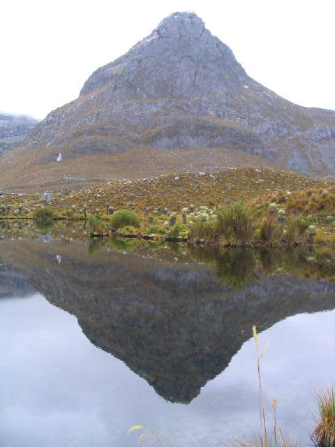 te a little before hiking.
The next morning we woke up, had a good breakfast, took the group photo above, and headed out at about 9am. The idea was to do a short hike to, again, help with acclimation. We hiked about 3.5 hours to a place called Laguna Verde and was greeted by a 20-minute hailstorm. When the storm passed, we did a bit of hiking around the campsite. This photo is a reflection of a mountain called Campanillas Negro on the lake. Thomas told us that there two enormous, man-made waterways that run the length of the park built from the tops of two high peaks in the park to bring fresh water to the two towns Guican and El Cocuy.
The next morning we left Thomas, Paola, and Juan Carlos at Laguna Verde and headed to Laguna Plaza. This was my first big challenge. We had to pass over a peak called Cusiri and it nearly broke me. I was not prepared for such a tough climb. The pass was about 4400 meters and I realized how unprepared physically I was for climbing like this, even after living in Bogota for 2.5 years. But, I made it over and arrived at Laguna Plaza about 30 minutes after Rainier and Phillipe arrived. On the night we stayed, there were about 20 other tents, which is considered very crowded. People love Laguna Plaza because it is surrounded by three impressive and famous mountains called Pan de Azucar (Sugarbread), El Diamante (The Diamond), and Toti (no idea the translation). If the weather conditions are conducive, you can wake up early in the morning and see El Diamante shine brilliant yellow and orange colors; colors, according to Erik, that distort digital photos. But when we woke up at 5am to hike to a good spot to see El Diamante, Erik said it was too cloudy and we went back to sleep. But by 8am when we left camp, the sky had cleared and El Diamante, Pan de Azucar, and Toti showed us a little of what they were made of (left, flat: Pan de Azucar. middle: El Diamante. Toti (to the right on the panoramic)). At Laguna Plaza, the decision was made to move Bart out of Phillipe and Rainier's tent and into my tent to try to help with the frigid overnight temperatures. We figured having two bodies in the tent would help more than just on
 e.
e. So we left for our next camping spot, Laguna de Panuelo (Tissue Lake). This was more of a long hike than a difficult one. We hiked for almost 8 hours and passed two peaks, the last one more difficult because it was close to the end of the hike. Now might be a good time to describe how, although we encountered rain for 5 of the 6 hiking days, we managed to stay relatively dry. Erik had luckily got us all motivated to make early departures from our
 camping sights while the weather was nice during the morning hours. By the time it reached the early afternoon hours, the weather worsened and clouded up almost every day. The hike to Panuelo was when the group realized that the weather was going to behave like this more or less throughout the time we were in the park so we were prepared for early wake-up calls and quick tent set-ups in the afternoon. The photo at the left was from the top of the second peak at about 4300 m, Laguna de Panuelo is at the right, back. The other photo is from Panuelo the next morning (the blue tent to the right is where I slept). I didn't sleep well that night because I wasn't accustomed to having another person in the tent with me. Bart didn't sleep well either because he still wasn't accustomed to the altitude yet.
The next morning, we headed out early. Everyone was fired up because it was going to be the day that we pass the Valle de los Cojines (Throw Pillow Valley), the valley that is most famous in the whole park and what many hikers who do this trip want to see. For me, the trip was a turning point. Meaning if anyone (including myself) wanted to back out of the rest of the trip for whatever reason (injury, doubt, etc), they could easily make it back to the Cabanas where we started. If not, they were committed to 4 or 5 more days of tough climbs of over 4400 meters and freezing cold nights. Without any doubt (or injury), we were all ready.
The day started with a climb over a pass called El Castillo (about 4500 m) and then a decent into the valley. We stopped and had lunch near one of the hundreds of pure water sources in the park. The water from the rivers? You can dip your bottle into it and drink it straight, without filters or treatment. The water is tasty and cold. If you wanted water from lakes, it is recommended you filter it but there are people who drink lake water straight from them too. Below are two photos from L
 os Cojines. The first is one up close of the group posing. As you can see the Cojines are like big lilly pads that you need to jump onto in order to move forward. There was a bit of risk involved. If you jumped onto a bright greed Cojin, you'd be safe. The surface is hard and can support your weight. If you were trapped and had to jump onto a brown one or one that didn't look healthy, you ran the risk of falling straight through it into the water. The water was about knee-deep and muddy. Thankfully, I made it through, but with a couple of close calls. The second is a shot from after we passed through them and were heading up to the next campsite near Laguna El Avellanal.
 When we arrived at El Avellanal, we were in the clouds and a heavy mist was in the air. I couldn't
 see the lake at all and managed to hurt my knee on the final climb up. It wasn't bad, but it did slow me down a bit. We ate an early dinner and slept when the sun went down. When we woke up, however, it was a different story. The sky was super clear and it lit up the surrounding landscape. See the ph
 otos above. After breakfast...let me digress a little on the food that we brought. Erik advised us to bring enough food for 7 days (we made the trek in 6). Thankfully, everyone got along well enough to share food and cooking/cleaning responsibilities. Unfortunately, between the 6 of us, everyone brought (essentially) the same thing. There didn't leave much variety: pasta at least twice a day with tuna; a canned vegetable, soup, or any combination of these three. We were lacking proteins and we got creative toward the end but we managed to eat fairly well. I haven't touched pasta since I got back.
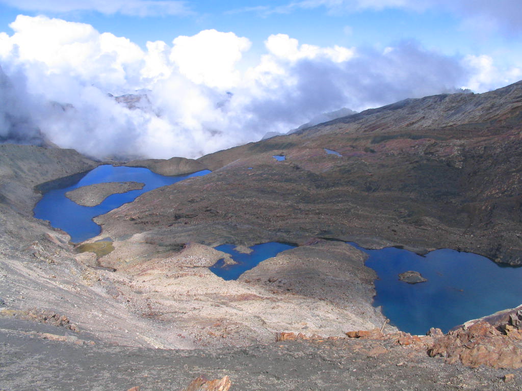
We finished breakfast and Erik informed us that the last two days of hiking were pretty tame. Tame meaning we've been at high altitudes for so long that climbing up from 3700 m to 4500 m wasn't an issue anymore. And it wasn't. It did become easier. We climbed the highest peak on the trek that morning, a peak of 4650 m (or 4800 m on the map, depending on which source you look at...either way it was a tall peak) called Boqueron de la Sierra. And the view from the other side was nice...Laguna de Isla and a glacier with a recent avalanche awaited us. This was our view.
We continued to our last camping spot on the trek at a lake called Laguna Grande de los Verdes. Again, we arrived in the afternoon in the clouds and had a freezin
 g cold night. But the mood was different because everyone knew that the trek was almost over and began to feel more relaxed. When we left the next morning, we got a good view of the lake as we walked toward the Cabanas near Guican. It was sort of our 'This-is- the-last-good-look-at-the-national-park-before- we-head-back-to-Bogota' view.
As a tour the experience was good. But in the back of my mind, I don't know if we really needed Erik at all. The trails were well-marked there was no danger of guerrillas. I talked to a few of the others in the group and they agree that we could have gone through alone. Furthermore, I got the feeling that Erik wasn't really a good definition of a guide; he wasn't the least bit prepared for accidents. He didn't even have the basic first aid kit.
All in all it was a great trip and I'm glad I did it. Now, I have mixed feelings; you know when you have a goal in your immediate future and it's really important to you and you finally accomplish it? It's a sort of satisfied/empty feeling that I have.
posted by Poor But Happy @ 9:17 PM
3 comments
![]()
![]()

3 Comments:
Hola Adam, que rico que caminó por esas montañas tan bellas y que envidia. Desde la montaña más alta de Venezuela se ven los picos del Cocuy y siempre pensé que algún día iba a ir, ahora me parece un poco lejana es idea, pero tal vez lo haga un día y tal vez siga su consejo y no llevo guia. ;-) Vero
hola vero! como te ha ido? si si creo que si tu y nate quieren, yo puedo guirar a uds por el camino. lo conozco muy bien y es muy seguro. pero andale porque andrea y yo vamos a salir en seis meses! saludos a nate. adam
Yo estoy presa en mi master. Pero guarde su bitacora para que Nate y yo la podamos usar cuando sea que vayamos ;-) Un abrazo. Vero
Post a Comment
<< Home