Strange sight
I was walking back to my apartment this afternoon and I saw two street kids playing on the sidewalk, punching each other while their fists were clenched with transparencies for an overhead projector. How often do you see that?
I was walking back to my apartment this afternoon and I saw two street kids playing on the sidewalk, punching each other while their fists were clenched with transparencies for an overhead projector. How often do you see that?
Occasionally, a young girl arrives in the middle of the school year and would like to be a student. More often than not, the student is given an admission test to see what her level of English is. This morning I was asked to correct her test and give my best judgment as to whether or not her English was at the level of 8th grade (she is intending to enter as an 8th grader). But to my dismay, the test itself had as many if not more errors in spelling, punctuation, and grammar than her responses did. I was embarrassed to be working there. Imagine if she had come from an American school (there is a new student in one of my 8th grade classes whose former school consisted of all but 2 subjects taught in English) and were asked to complete it. She would turn to her parents and ask them to keep shopping around.
About 3 months ago, I signed on with this headhunter called Search Associates which is based in the US but finds jobs for teachers who want to teach overseas. Although last year, ISS (another company with similar services) rejected my application for whatever reasons they had, Search Associates decided to represent me and invite me to their next job fair. Initially, I thought that attending job fairs was a foregone conclusion because of my current location and financial status but after weighing the options and realizing that these job fairs have a 50-75% success rate, I decided to attend their upcoming one in Carmel, California the weekend of February 3,4, and 5th.
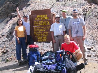
I just got back from el Cocuy on Wednesday. On the link, run your mouse over the boxes for some info. Being there and doing this trek was one of the most amazing experiences I've ever had. Four words come to mind (and if you know the song it's a bonus): joy, pain, sunshine, and rain. It's better if I start with the people I was with. To the left is a photo taken by someone who had apparently never used (seen?) a digital camera before. Everyone is in their late 20's to mid-30s. Starting from the left: Juan Carlos: born in the US, lived in England for most of his life, now lives and wor
 ks in Chicago but calls himself a Colombian; Patricia: the girlfriend of the guide Erik, who is standing next to her. She is a Colombian dentist who has walked through the park on several previous occasions but still cannot find her way around. Erik: the guide. He's from Holland and is a nice guy who knows the park very well and is well-traveled throughout the world. Paola: the girlfriend of the other guide, Thomas (standing next to me). I don't know much about her other than that she's Colombian and a novice trekker. Rainier: a free-lance journalist also from Holland. A very advanced trekker who almost always arrived to a resting point or meeting point first. Very cool guy. Phillipe: from Zurich. I didn't talk to him much and don't know what he does for a living. He has done many mountain treks in the Alps and was very capable during this trek. Bart: works in logistics for Heineken in Holland. Nice guy, a bit nerdish. He was one of the slowest trekkers because he was the last to arrive to the high altitudes of Colombia and had a hard time acclimating. Thomas: the other guide. He's also from Holland and met with Erik 2 years ago and decided to start their business together. I didn't talk to him much but got a good impression of him. And I'm on the far right.
 te a little before hiking.
 e.
e. So we left for our next camping spot, Laguna de Panuelo (Tissue Lake). This was more of a long hike than a difficult one. We hiked for almost 8 hours and passed two peaks, the last one more difficult because it was close to the end of the hike. Now might be a good time to describe how, although we encountered rain for 5 of the 6 hiking days, we managed to stay relatively dry. Erik had luckily got us all motivated to make early departures from our
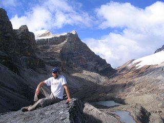
 camping sights while the weather was nice during the morning hours. By the time it reached the early afternoon hours, the weather worsened and clouded up almost every day. The hike to Panuelo was when the group realized that the weather was going to behave like this more or less throughout the time we were in the park so we were prepared for early wake-up calls and quick tent set-ups in the afternoon. The photo at the left was from the top of the second peak at about 4300 m, Laguna de Panuelo is at the right, back. The other photo is from Panuelo the next morning (the blue tent to the right is where I slept). I didn't sleep well that night because I wasn't accustomed to having another person in the tent with me. Bart didn't sleep well either because he still wasn't accustomed to the altitude yet.
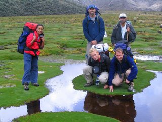
 os Cojines. The first is one up close of the group posing. As you can see the Cojines are like big lilly pads that you need to jump onto in order to move forward. There was a bit of risk involved. If you jumped onto a bright greed Cojin, you'd be safe. The surface is hard and can support your weight. If you were trapped and had to jump onto a brown one or one that didn't look healthy, you ran the risk of falling straight through it into the water. The water was about knee-deep and muddy. Thankfully, I made it through, but with a couple of close calls. The second is a shot from after we passed through them and were heading up to the next campsite near Laguna El Avellanal.
 When we arrived at El Avellanal, we were in the clouds and a heavy mist was in the air. I couldn't
 see the lake at all and managed to hurt my knee on the final climb up. It wasn't bad, but it did slow me down a bit. We ate an early dinner and slept when the sun went down. When we woke up, however, it was a different story. The sky was super clear and it lit up the surrounding landscape. See the ph
 otos above. After breakfast...let me digress a little on the food that we brought. Erik advised us to bring enough food for 7 days (we made the trek in 6). Thankfully, everyone got along well enough to share food and cooking/cleaning responsibilities. Unfortunately, between the 6 of us, everyone brought (essentially) the same thing. There didn't leave much variety: pasta at least twice a day with tuna; a canned vegetable, soup, or any combination of these three. We were lacking proteins and we got creative toward the end but we managed to eat fairly well. I haven't touched pasta since I got back.
 g cold night. But the mood was different because everyone knew that the trek was almost over and began to feel more relaxed. When we left the next morning, we got a good view of the lake as we walked toward the Cabanas near Guican. It was sort of our 'This-is- the-last-good-look-at-the-national-park-before- we-head-back-to-Bogota' view.